Exploring Almost Forgotten Gravesites in the Great State of Ohio

Dedicated to cemetery preservation in the great state of Ohio


"A cemetery may be considered as abandoned when all or practically all of the bodies have been Removed therefrom and no bodies have been buried therein for a great many years, and the cemetery has been so long neglected as entirely to lose its identity as such, and is no longer known, recognized and respected by the public as a cemetery. 1953 OAG 2978."

Friday, June 30, 2023

From the Ohio Department of Commerce - Division of Real Estate and Professional Licensing: The Cemetery Grant Program for Fiscal Year 2024 is now open - taking On-Line Only Applications - through July 31, 2023

The  "Ohio Cemetery Grant Program for 2024"  is now open starting June 30, 2023 through July 31, 2023 to apply for Fiscal Year 2024.

~*~*~*~*~*~*~*~ 

Quoted from the website.:

"CEMETERY GRANT"

"The Ohio Department of Commerce Division of Real Estate and Professional Licensing (REPL) is pleased to announce the availability of the FY2024 Cemetery Grant for qualifying not-for-profit and local government cemeteries

Allowable grant requests include those to defray costs of exceptional cemetery maintenance or training cemetery personnel in the maintenance and operation of cemeteries. Eligible applicants shall be cemetery operators properly registered with REPL, be a documented not-for-profit entity under the IRS tax code and be in compliance with any applicable endowment and/or preneed cemetery merchandise and services trust accounts. The REPL Superintendent is accepting only online applications.

Please gather all information prior to application entry. Once you start the application, the information entered cannot be saved and if you exit out of the application you will lose all information previously entered. 

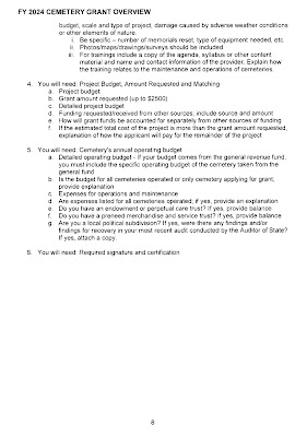
The Cemetery Grant application instructions are being provided as a worksheet guidance document only. This will allow you to gather all of the necessary information prior to submitting the grant application online.

***You can find the grant instructions here.***

The application must be answered completely to be considered for grant funds and submitted no later than July 31, 2023."

Contact: 

CemeteryGrants@com.state.oh.us. 

~*~*~*~*~*~*~


~*~*~*~*~*~*~
Main Page for Cemeteries.:
https://com.ohio.gov/divisions-and-programs/real-estate-and-professional-licensing/cemeteries
~*~*~*~*~*~*~
Link to the Guides and Resources for the cemetery grant program.:

https://com.ohio.gov/divisions-and-programs/real-estate-and-professional-licensing/cemeteries/guides-and-resources/cemetery-grant
~*~*~*~*~*~*~
****As in years past, the Cemetery Grant Program is only open to Active Cemeteries (those that have had interments in the past 25 years) that are Registered or those that Should be Registered AND are Not-For-Profit Cemeteries.
  ~*~*~*~*~*~*~
****Please keep in mind as was true for previous years, 
the For Profit Cemeteries -- such as those owned and operated by StoneMor, for example -- are NOT eligible to receive any funds from the Cemetery Grant Program in Ohio. 
(D) Sections 4767.02 to 4767.04 of the Revised Code do not apply to or affect a family cemetery or a cemetery in which there have been no interments during the previous twenty-five calendar years. As used in this division, "family cemetery" means a cemetery containing the human remains of persons, at least three-fourths of whom have a common ancestor or who are the spouse or adopted child of that common ancestor.
~*~*~*~*~*~*~
****If you have any questions or require additional assistance, please contact the Division at 614-466-5384 or CemeteryGrants@com.ohio.gov.****
~*~*~*~*~*~*~

Saturday, June 24, 2023

Did this cemetery ever really exist? - VanDillingham Church Cemetery - Perry Township - Franklin County, Ohio - A 1930s WPA Cemetery Plat Map that is unlike any other!

The VanDillingham Church Cemetery shown as being located in Perry Township, Franklin County, Ohio has a W.P.A. cemetery plat map unlike any other!  I couldn't find the cemetery name on Find A Grave, or anywhere else. That was just the start of a journey to learn more about this unusual W.P.A. cemetery plat map - and it hasn't ended yet.  

Fortunately for me, Grace at the Columbus Metro Public Library did help answer the question about the VanDillingham Church Cemetery's existence.  It does exist, but not under that name or in that township!  It is the Old Baptist Church Cemetery in Truro Township, Franklin County.  

It is also called the Primitive Baptist Church Cemetery now on Find A Grave.

See the comparison below.:


~*~*~*~*~*~*~*~*~*~*~*~*~
Below is a 3-image collage showing a more close up view of some of the names written on the WPA Cemetery Plat map for this cemetery named "VanDillingham Church Cemetery".

~*~*~*~*~*~*~*~*~*~*~*~*~
It is evident from the three photo collage below that the Official Project Numbers of 465-42-3-467 & 665-42-3-232 that are associated with the WPA Program and appears in the "Legend of Wars Box" is missing for this VanDillingham Church Cemetery.   Only a partial listing of the designated numbers for the wars, a short history of the cemetery, and the size of the cemetery are shown there, however.  
~*~*~*~*~*~*~*~*~*~*~*~*~
Emphasis appears to be more about the platting of this cemetery as referenced by the "Note:  "Measurements at edges of plat show method of plotting unmapped cemetery."  And, we can see in the very right-hand corner is the tiny, but nevertheless important, notation of:
 "Ohio State W.P.A. Project Number 99".  This Project Number has never been seen on a WPA Cemetery Plat Map before. Thus, additional research is needed; and so this mystery continues!
~*~*~*~*~*~*~*~*~*~*~*~*~ 
Including here is my response from the Franklin Chapter of the Ohio Genealogical Society to my question.:

"
Consider this a Mystery NO MORE."

We notice that the first drawing you enclosed had 

reference to State Route 256 along the left side

 of the cemetery and Jackson St. on the right side.  


We  were able to triangulate these two roads and

 discovered the Cemetery is Not in Perry Township

 but is actually in Reynoldsburg, Ohio Truro

 Township about 17 miles to the southwest of Perry

 Twp..


S.R 256 is also known in Reynoldsburg as Lancaster Ave. 


This cemetery is now known as the Old Primitive

 Baptist Church Cemetery - GPS

 Coordinates 39.952385, -82.800625.  


You will see a second much bigger cemetery across

the road which is known as the Silent Home

Cemetery.

You can find a number of photos of

 the Primitive Church Cemetery on Find A Grave.


The Reynoldsburg Street Department now

 maintains the Primitive Baptist Church Cemetery,

 Seceder Cemetery, and Hill Road Methodist

 Cemetery.


We found this Online.

“BAPTIST (PRIMITIVE BAPTIST) CEMETERY - Established 1844. Located at the intersection of Route 256 & Jackson street in Reynoldsburg. Still maintained by the church. The Church is still active. GPS Coordinates: N 39° 57.153 W 082° 48.015.  Although the church is called Friendship Primitive Baptist Church, the adjoining cemetery is referred to simply as "Primitive Baptist Cemetery." The stones date from the 1830s. It is small -- approximately 100-150 burials. 

There had not been any burials there for many years until the summer of 2007.  

The cemetery was restored in 1998.


Reynoldsburg was a key spot on the Underground Railroad because of its location and the number of abolitionists here. 

Slaves, traveling north from the Ohio River, were sent from Columbus along East Friend Street (East Main Street) to Reynoldsburg. The David Graham House, 1312 Epworth Avenue, still standing after 150 years, was a major Underground station. There was also a cave off Main Street near Waggoner Road, a room under the Old Primitive Baptist Church on South Jackson Avenue, and the Alexander W. Livingston seed farm, among others, that provided hiding during the day and transportation at night for escaped slaves.

The cemetery was Recorded/Indexed ca 1940.  Primitive Baptist Church Cemetery, Also known as Baptist Church Cemetery, Reynoldsburg, Truro Township, Franklin County, Ohio. Earliest burial indexed: 1818.”

Friday, June 23, 2023

The W.P.A. Cemetery Plat Maps for Franklin County have been added to the right sidebar of the blog.

 The W.P.A. Cemetery Plat Maps for Franklin County have been added to the right sidebar of the blog in .jpg format, converted from another format.

As is the case for other Ohio counties, this collection of W.P. A. Cemetery Plat Map albums are grouped under the name of the township where they are located in.

There are page numbers on each page.  

This cemetery map collection does have the Cemetery Index Page, however, there is no cemetery locator map included for it.  

There is a small listing of unknown burial locations for veterans whose names appear on the top right portion of the Cemetery Index Page. Possible burial locations for some of them have been added below. :

*******************
Project Title Page 
(Below)
~*~*~*~*~*~*~*~

The Franklin County W.P.A. Cemetery Plat Maps are quite unique in nature due in large part to the bustling city of Columbus which is not only the county seat but also the State Capitol of Ohio.  

There is a vast variety of types of cemeteries dotting the landscapes of Franklin County.  Each one offers reasons for exploration and expanding one's knowledge about them through studying the lives of those who found peace and rest on their grounds. Each cemetery can rightfully claim its own important place in the history of the city and the county.

The townships in Franklin County, Ohio are.:

Blendon, Brown, Clinton, Franklin, 

Hamilton, Jackson, Jefferson

Madison, Mifflin, Norwich

Perry, Plain, Pleasant, Prairie

Sharon, Truro, Washington

~*~*~*~*~*~*~*~

Referencing the Glenrest (AKA Glen Rest) Cemetery.:

  Glenrest (AKA Glen Rest) Cemetery is shown as situated between Truro Township, Franklin County, and Licking County.


~*~*~*~*~*~*~*~

The following cemeteries have their own dedicated albums in this collection.:

Green Lawn Cemetery which has map pages from 68 through 134; and Green Lawn Abbey with pages 135 and 136 are together and contain the largest number of interments existing in any Franklin County cemetery.  

Noting also that Page 122 - Section 71-  indicates the most veterans burials for a single section. 

(See below). 


And, the other cemetery is.:
Union Cemetery in Clinton Township with Pages 221 through 236 are listed in the cemetery's own album.

~*~*~*~*~*~*~*~

For the remainder of other cemeteries in this collection that have multiple section pages, those are included along with map pages of smaller cemeteries under the township where they are located. It is a good idea to check the Key Map Page for a cemetery first to see the sections on a map and their respective page numbers.  

Every township album of cemetery plat maps lists the cemetery pages in page number order from lower to higher in the description box for the album.   

Since there is no Cemetery Locator Map page included with this collection, the Cemetery Index is a crucial tool to reference for locating cemeteries by name and their corresponding page number.  

~*~*~*~*~*~*~*~

There are 22 map pages that are saved in the "Multiple Townships / Smaller Cemeteries" Album.  This indicates that the map pages have more than one cemetery and more than one township name on the map page.

~*~*~*~*~*~*~*~

Note Silent Home Cemetery's Title Page shown below.  Of particular interest is the short but telling statement provided under "History.": 

"Established 6-23-1880.  

Previous Record Destroyed." 

~*~*~*~*~*~*~*~

Forest Lawn Memorial Park in Truro Township is missing its last page which is page number 48.

~*~*~*~*~*~*~*~

Spotlighting the Camp Chase Confederate Cemetery which is of particular interest for those researching Confederate Civil War veterans. It is located in Franklin Township.  The Cemetery Index page shows that the pages are from 20 through 24.  Page 20 is missing, however. It would have been the Title Page.  

Page 21 is the Key Map. 

 
~*~*~*~*~*~*~*~
The above examples in the Franklin County W.P.A. Cemetery Plat Map collection contain only a small fraction of all of the maps that offer unique history and diversity for researchers and those spending time walking the grounds at cemeteries in Franklin County, Ohio.  Many are searching for veteran markers and these maps can help!  

These W.P. A. Cemetery Plat Maps were created during the 1930s - the decade of the Great Depression.  So it is that these many decades later they continue to have their special relevance for us today.  They can serve as a starting point for someone just learning about a cemetery.  They can even pique the interest for those who simply enjoy lingering among the inspiring monuments and reading the touching epitaphs and inscriptions carved on flat and slant style markers. 

~*~*~*~*~*~*~*~

Whatever the reasons, these cemetery plat maps should be preserved and made available for the public to access and view - not hidden away atop a filing cabinet inside a dusty hard-covered book where in some cases, those working around them may not even know they exist or what they are.

~*~*~*~*~*~*~*~

This writer/researcher by the Benjamin Penn Duvall monument at Green Lawn Cemetery in Columbus. He was my third great-grandfather.


~*~*~*~*~*~*~*~