Paulding County, Ohio is comprised of the following townships.:
Auglaize Township
Benton Township
Blue Creek Township
Brown Township
Carryall Township
Crane Township
Emerald Township
Harrison Township
Jackson Township
Latty Township
Paulding Township
Washington Township
The collection of Paulding County W.P.A. Cemetery Plat Maps follow the same format adopted by most other Ohio counties that have been researched to date. There is a Cemetery Index and Cemetery Locator Map.
All cemetery map pages are numbered.
The map images are in good condition overall and readable, however, the veterans names are in a smaller size font in the listings, particularly so for the smaller size cemeteries and family cemeteries where the veterans names are shown inside the maps themselves at the plot locations. For each veteran the war number designation, which is shown in a circle, matches the listing for the wars in the "Legend of Wars" Section. This is shown in the lower right-hand corner of the map page inside of an outlined box containing the Official WPA Project Numbers; and the size of the cemetery shown in acres. There may or may not be a short description included under the History heading.
Larger size cemeteries have their own Title Page and Key Map if there is more than one section for a cemetery.
Please check out the Paulding County cemeteries as shown on Find a Grave. It is an excellent research resource. This is particularly true for Paulding County because many contributors have included detailed descriptions about a cemetery itself with additional information provided about some of those buried at the cemetery.
A sampling of unique map pages.:
Paulding Township - Live Oak Cemetery - Block F - Nich. G. Saurwein, Lot 86 - Grave 6.
The war for this veteran is listed as Number 21.
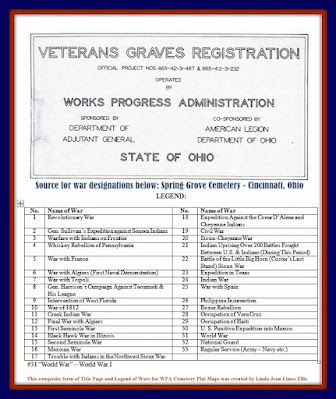
War Number 21 was seldom listed in these W.P.A. Cemetery map collections. It is designated as having been one of the 200 American Indian uprisings that was fought following the American Civil War.
See the numbered listing of the wars, rebellions, uprisings, etc. below.:

Also, note.:
Young Cemetery in Paulding County's description:
(Taken from the History of Grover Hill by Laurence R. Hipp, published in 1971.):
And:
From the same publication this historical account was provided for the Wilson Cemetery.:
"Amelia Pleasants was the last person to be buried in the Wilson Cemetery, in the year 1914. This small cemetery located in the Southeast Quarter of Section 9 of Washington Township, was established very early by the residents of the Black community in the immediate area. On January 3, 1880, Harrison and Caroline Wilson deeded to the trustees of the African Methodist Episcopal (AME) Church the land for this cemetery; the deed is recorded in Volume 28, page 180, Paulding County Record of Deeds. The Black settlement in the area also contained a church and a school. Except in dry seasons, this cemetery cannot be reached by auto. It is located one mile east and two and one-quarter miles north of Roselms, thence west along a fence-line, a distance of about eighty rods. During the winter months, when the tree foliage is gone, the cemetery may be seen from the road south of the cemetery at a point near the former home of Pearl H. and Mary Taylor.
However, Find a Grave has Fred Allen Moore as being the latest burial at the Wilson Cemetery.:


%20&%20YOUNG%20(COLORED)%20-%20VETS%20NAMES%20-%20PAGE%2083.jpg)
%20NEW%20&%20OLD%20SECTIONS%20-%20VETS%20NAMES%20-%20PAGE%2066.jpg)