Exploring Almost Forgotten Gravesites in the Great State of Ohio

Dedicated to cemetery preservation in the great state of Ohio


"A cemetery may be considered as abandoned when all or practically all of the bodies have been Removed therefrom and no bodies have been buried therein for a great many years, and the cemetery has been so long neglected as entirely to lose its identity as such, and is no longer known, recognized and respected by the public as a cemetery. 1953 OAG 2978."

Showing posts with label WPA Cemetery Plat Maps. Show all posts

Thursday, May 15, 2025

The Ashland County W.P.A. Cemetery Plat Maps have been added to the right sidebar of the Blog.

 The Ashland County W.P.A. Cemetery Plat Maps have been added to the right sidebar of the blog.

The original paper map pages are in a hard cover book at the office of the Ashland County Recorder. Erin Beebe is the Recorder and she has photographed them in their original condition.
~*~*~*~*~*~*~
Sharing this example.:

Selser Cemetery in Milton Township, Ashland County, Ohio.: 

The "Ohio Genealogy Express" lists his name as Frederick Sultzer

~*~*~*~*~*~*~
Unlike most W.P.A. Cemetery Plat Map collections in other Ohio counties, Ashland County's cemetery map pages containing multiple cemeteries on one page are all of the same township. Thus there are no "Multiple Townships / Smaller Cemeteries" category in their collection. 

Monday, April 14, 2025

The Auglaize County W.P.A. Cemetery Plat Maps have been added to the right sidebar of the blog.

The Auglaize County W.P.A. Plat Maps have been added to the right sidebar of the blog.
~*~*~*~*~*~*~*~

Auglaize County, Ohio is comprised of the following townships.:

Clay

Duchouquet

German

Goshen

Jackson

Logan

Moulton 

Noble

Pusheta

Salem

St. Mary's

Union

Washington

Wayne
~*~*~*~*~*~*~*~
The Auglaize County Ohio W.P.A. Cemetery Plat Maps are in pristine condition!  The pages are numbered and the maps are in very good readable condition. 

~*~*~*~*~*~*~*~
The originals for these map pages are at the Auglaize County Recorder's Office in the .pdf format.
~*~*~*~*~*~*~*~
As is the case with these W.P.A. Cemetery Plat Map collections from other Ohio counties, the highest number of veteran burials are for those who served in the Civil War - Number 19.  

There are veterans who served in other wars as well and are noted as such with their number in a circle. 

Fort Amanda Memorial Park is the resting place for two known Revolutionary War veterans.:
Peter Sunderland
Willian Taylor

(age of William Taylor on Find a Grave shows 110 -111, and thus is being investigated.)
~*~*~*~*~*~*~*~
Some map pages present with the veterans names in the more traditional format of listing the veteran's burial location - Section Lot Grave War Name - while other maps show the veteran's name by his gravesite inside the map itself.  

This is a finer point to keep in mind. Below is a side-by-side example that actually occurs on the same map page.: 

~*~*~*~*~*~*~*~
Mentioning that the name for Fort Amanda Memorial Park AKA Fort Amanda Cemetery in Logan Township has been corrected for it on Find a Grave to reflect this name. 

Previously, it had been erroneously identified as being a National Cemetery.  Upon further investigation, it was confirmed that this cemetery is not an official National Cemetery.

When the W.P.A. Cemetery Plat Map was created for it, the word (Military) was included for its name.:

~*~*~*~*~*~*~*~
The Walnut Hill Cemetery in Goshen Township has a penciled in date at the bottom of some of its pages of 3/28/40 which I take it to mean March 28, 1940.  1940 is among the later years when these cemetery plat maps were drawn up in the W.P.A. program which began in the mid to late 1930s during the Great Depression. 


~*~*~*~*~*~*~*~
Thus, if you are researching veteran burials in Auglaize County, Ohio, these W.P.A. Cemetery Plat Maps would be a wonderful place to start!

Friday, February 28, 2025

The Ashtabula County W.P.A. Cemetery Plat Maps have been added to the right sidebar of the blog.

A link to the WPA Cemetery Plat Maps for Ashtabula County has been added to the right sidebar of the blog.  

Along with the customary Cemetery Index Page, there is a Cemetery Locator Map, and a handy listing of cemeteries shown under the township name where they are located.  

These cemetery plat maps are posted in addition to the Ashtabula County G.I.S. website where the cemetery plat maps are further linked to the exact GPS locations on a current road map.
~*~*~*~*~*~*~*~  

Ashtabula County is Ohio's largest county that is comprised of 28 townships.
~*~*~*~*~*~*~*~

Buried in Section F at the East Lenox Cemetery in Lenox Township is American Revolutionary War veteran Isaac Williams whose Find a Grave memorial contains an amazing amount of family history!  He died at the age of 90. 
~*~*~*~*~*~*~*~

Civil War Soldiers and Sailors Monument on Find a Grave  

********
The small Pioneer Cemetery in Windsor Township has a total of 25 memorials on Find a Grave.  The cemetery contains burials of four American Revolutionary War veterans. The W.P.A. Cemetery Plat Map lists their names; and they are the only veterans listed for this cemetery.:

Solomon Griswold

    Capt. Jonathan Parker

Steven Winslow

Giles Loomis 

~*~*~*~*~*~*~*~

The Evergreen Cemetery in Pierpont Township is the final resting place for Seth A. Marvin who was approximately 103 years old when he passed away. His biography states that he cast his first vote for General George Washington for America's first President.  He lived long enough to vote for Abraham Lincoln for President.  

~*~*~*~*~*~*~*~
It is worth a visit to Ashtabula County's cemeteries - both large and small -- where you will find a unique history that abounds within the grounds of them all! 

Monday, January 6, 2025

The Delaware County W.P.A. Cemetery Plat Maps are now up on the right side-bar of the blog.

 WPA CEMETERY PLAT MAPS - DELAWARE COUNTY, OHIO.

Townships in Delaware County, Ohio.:

Berkshire

Berlin

Brown

Concord 

Delaware 

Genoa 

Harlem  

Kingston

Liberty

Marlboro 

Orange

Oxford

Porter

Radnor

Scioto

Thompson

Trenton

Troy

**********

This collection of W.P.A. Cemetery Plat Maps is excellent for quality of the images.  All pages are appropriately numbered.  

It is quite evident when analyzing these pages of cemetery plat maps and the listings of the names of veterans, that Delaware County has a more than an average number of American Revolutionary War veteran burials in its cemeteries. A researcher can grasp a real sense of early American history reviewing these cemetery plat map pages of the veterans names and the wars they served in. 

Seeing the names of so many soldiers who fought in the American Revolution and were buried in Ohio, and specifically in Delaware County, brings a reality to us that the histories we have read about them in books and on the Internet are true. 

For example, The Galena Cemetery cemetery has six burials listed with the number "1" denoting Revolutionary War,  as shown in the Legend Box. 

Mill Creek Cemetery in Scioto Township lists two American Revolutionary War veterans, one of them was Sgt. William Warrington (Page 27 lists his name as William J. Warrington, however, other references show his name as  William E. Warrington) who saved the life of General George Washington.  

Below from FamilySearch.:  

https://ancestors.familysearch.org/en/LWSB-F7P/sgt.-william-e.-warrington-1754-1852
**********

Six Revolutionary War veterans are listed on this page for the Sunbury Cemetery.:

**********

Link to the Columbus Metro Library - Digital Collection 

And this link.

**********

Thus, even though Delaware County's veteran burials are dominated by those who fought in the Civil War, which is the case at other Ohio counties; I feel Delaware County's American Revolutionary War veteran burials number a close second.

Tuesday, December 10, 2024

The Henry County W.P.A. Cemetery Plat Maps have been added to the right sidebar of the blog.

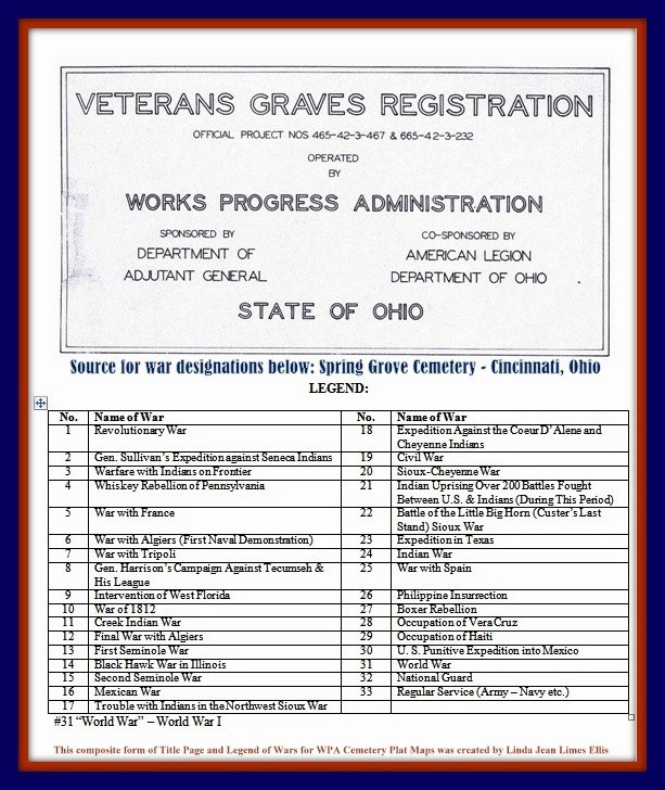
The W.P.A. Cemetery Plat Maps for Henry County have been added to the right side-bar of the blog. 

~*~*~*~*~*~*~

Also, please note that the Henry County WPA Cemetery Plat Maps are now online in .pdf format on at the Henry County Engineer's website.:
  Search under the heading Maps/plat books Map Resources.  

At the bottom are the WPA Cemetery Plat Maps

~*~*~*~*~*~*~

I am so pleased to share that the Henry County W.P.A. Cemetery Plat Maps are in excellent condition with all of the pages numbered. 

There is a Cemetery Index and a Locator Map for the map collection. 

~*~*~*~*~*~*~*~

Here is a link to the Henry County, Ohio cemeteries on Find a Grave.

~*~*~*~*~*~*~

Henry County, Ohio is comprised of the following townships.:

Bartlow

Damascus

Flatrock

Freedom

Harrison

Liberty

Marion

Monroe

Napoleon

Pleasant

Richfield 

Ridgeville

Washington

~~~~~~~~~~~~~~~~~~~~~~~~~~~~~~~~~~~~~~~~~

The Henry County Cemetery Index lists 55 cemeteries with 23 cemeteries that have religious affiliation connections. 

The St. - i.e. Saint cemeteries have the largest number with 14.  

Others include.:

Sacred Heart Cemetery - shown as Sacred Heart Catholic Cemetery on Find a Grave.  

This cemetery was previously known as St. Michaels, and Poplar Ridge Cemetery that was opened 1840 per Find a Grave. The cemetery photo shows an ornate cross tipped entrance arch constructed of thick heavy stone blocks. 

Not far beyond the entrance stands a large towering monument with a crucifix on top erected on a rise at the center area of the cemetery.  This is a magnificent monument that certainly would garner the attention of visitors even prior to passing through the entrance arch.

There are seven photographs posted for the Sacred Heart Cemetery on Find a Grave and these two are my favorites.:
*****
A long distance view of the grand stone entrance arch with the black iron fencing and gate.  In this picture just beyond the entrance is the tall memorial monument inside the cemetery for Rev. George A. Verlet.  

Also, a close up view photograph of Rev. Verlet's beautiful monument with its large crucifix on top reaching upward toward the heavens above all of the markers and monuments in the cemetery.  

The entire scene is peaceful and welcoming complete with its backdrop of the rural countryside.  It is easy to see the Sacred Heart Cemetery is regularly maintained.

~*~*~*~*~*~*~ 


For the Cole Cemetery's W.P.A. Cemetery Plat Map, the code for the Lot Category includes s.g.s. meaning single grave section. Under Section there are O.P. for Original Plat or 1-A for 1st Addition. 

On Find a Grave the Cole Cemetery shows an alternate name of Wait Creek Cemetery.

~*~*~*~*~*~*~

Other religious affiliated cemeteries include.: 

U.B. cemeteries - United Brethern (known by other names on Find a Grave.)


A link for the cemeteries on Find a Grave that either have the name of Lutheran or Lutheran as an alternate name.  

~*~*~*~*~*~*~

There is one cemetery named "Old Angel" - see W.P.A. Cemetery Plat Map below.  

On Find a Grave the cemetery is named Angel. 

However, the cemetery was named after a family with the surname of Angel.
Daniel Webster Angel.

~*~*~*~*~*~*~

Lastly, we'll take a look at the Gunn Cemetery.

Cyrus D. Gunn, Elijah Gunn, Jr., and Elijah Gunn, Sr., were all veterans.

~*~*~*~*~*~*~*~

"May 22 2015 – TheCrescent-News.  Defiance, Ohio"

"FLORIDA -- Nestled in a small, family cemetery just east of Florida, off Henry County Road 424, is the grave of a Revolutionary War soldier, Elijah Gunn Sr. The sun-splashed cemetery holds the graves of Gunn and many of his family members.

The Elijah Gunn Sr. Chapter of the Daughters of the American Revolution, of Napoleon, recently took on the project of restoring the headstone on Gunn's grave. The chapter was founded in 1975 with 12 charter members. It currently has 20 active members.

Julie Eberle, the regent of the Elijah Gunn Sr. Chapter of the DAR, said, "We were talking about a project for the DAR and decided that the deteriorated condition of Elijah's headstone was a project we could do."

Eberle said Homier's Monumental, of Defiance, worked on the headstone and placed a new one on Elijah's grave.

The new headstone will be dedicated in a DAR ceremony on Saturday, June 13 at 11:30 a.m. at the cemetery. To reach the cemetery, go east from the village of Florida for about two miles on Henry County Road 424. There is a gravelled pull-off area on the south side of the road. Visitors will walk on a sturdy wooden bridge across the canal to reach the cemetery.

Elijah Gunn and his wife, Anna, were early pioneers in Ohio and in the Florida area. He was born on Dec. 25, 1759 in Sunderland, Mass. He was the son of Nathaniel Gunn and a descendant of Jasper Gunn, who emigrated to America from the Highlands in Scotland in 1635. Elijah served in the Army of the Revolution.

In 1796, Elijah and Anna (Sartwell) and their children came with the Connecticut Land Company to survey the Western Reserve. Elijah was employed by the surveyors and Anna, who was the second pioneer woman to come to Cleveland, cooked for the party and was known as a "competent nurse" who spent her spare hours caring for the sick and dying and assisting young mothers. She also had a large family of her own to care for -- she had six children -- and she was not paid for any of the services she performed for the company.

The Gunn family stayed for three years in a log cabin in Cleveland and eventually moved to Waterville in 1815. Anna was given some land in Cleveland in 1803 by the Connecticut Land Company for her services.

A few years after their move to Waterville, the Gunns moved up the Maumee River near Florida and bought land from the government. Ownership of the present Gunn Family Farm and Homestead was deeded directly by the government in 1833 to Elijah Gunn Jr., the Gunns' son. Anna died in 1842 at the age of 84 and Elijah Sr. died in 1855 at the age of 95.

Elijah Gunn Jr. was born in Massachusetts and went with his family to Cleveland. He served in the War of 1812 and came back to Ohio shortly after the war. He married Eleanore Grant, a cousin of President Ulysses S. Grant, and they built a log cabin on the Maumee River. They were granted about 100 acres of land in 1833, which is the present Gunn Family Farm. At the time of his death in 1875, Elijah Jr. owned about 500 acres.

Elijah Jr. and Eleanore had six children, including William Gunn, and raised at least four orphans. Elijah Jr. died in 1875 and Eleanore in 1838. Elijah had a second wife, Dorcas and they had three children. Elijah, Eleanore and Dorcas are all buried in the Gunn Cemetery."

~*~*~*~*~*~*~ 

Sunday, November 17, 2024

The Fayette County W.P.A. Cemetery Plat Maps have been added to the right sidebar of the blog.

 The Fayette County W.P.A. Cemetery Plat Maps have been added to the right sidebar of the blog. 

Fayette County, Ohio is comprised of the following townships.: 
Concord, Green, Jasper 
Jefferson, Madison, Marion
Paint, Perry, Union, Wayne
~*~*~*~*~*~*~*~
Fayette County is part of the VMD = Virginia Military District in Ohio.
~*~*~*~*~*~*~*~
Fayette County was formed on March 1, 1810, from portions of Highland and Ross Counties.
~*~*~*~*~*~*~*~
This collection of W.P.A. Cemetery Plat Maps is complete with its Cemetery Index Page, and a 1940 Fayette County Road Map with Legend.

~*~*~*~*~*~*~*~
The original .pdf scans are located at the Fayette County Recorder's Office.  They were scanned as individual pages, (Search type “Book / Page”, Book Type “Cemetery Plat").

Thus, some maps do not have their map page number listed on them but the numbers are included in their titles in these .jpg images.
~*~*~*~*~*~*~*~ 
It appears that these W.P.A. Cemetery Plat Maps were created in 1924 which pre-dates the W.P.A. (Works Progress Administration) era of the 1930s, however, the  "OFFICIAL PROJECT NOS 465-42-3-467 & 665-42-3-232" identification is affiliated with them. 
See excerpts from the Fayette County Genealogical Society's publication below. (I am unsure if it is still available for sale by the society).:


~*~*~*~*~*~*~*~
The Evans Cemetery in this publication includes information that it may actually be located in Clinton County. 
****
~*~*~*~*~*~*~*~
On the W.P.A. Cemetery Plat Map for the Johnson Cemetery shown as being in Union but possibly Marion Township.:
The following interesting additional information was included that states the "Grave of Elizabeth D. Carr wife of Martin Carr 100' East of Fence Line of cemetery in wheat field." 
~*~*~*~*~*~*~*~
Fayette County is mostly a rural county with a great number of small family cemeteries that were still in existence 100 years ago that may have vanished by today.

The main purpose of these maps was to document the burial sites of veterans and are companion records to the individual veterans graves registration cards. However, as we see in the collection of these cemetery maps and some in other Ohio counties, there are any number of reasons to reference them. It is good to consider that unexpected hidden gems just might be there awaiting our discovery if we only take those extra steps to uncover them.

Thursday, September 12, 2024

The Miami County, Ohio W.P.A. Cemetery Plat Maps have been added to the right sidebar of the blog.

 The W.P.A. Cemetery Plat Maps for Miami County, Ohio have been added to the right sidebar of the blog.

~*~*~*~*~*~*~

These cemetery maps are clear and easy to read.  All pages are numbered.  

Unfortunately, not all map pages have their corresponding listing of the names of the veterans on either the map page itself or on a separate page. This is particularly true for some of the larger cemeteries.

The "Legend of Wars" box that is seen on the lower right of a cemetery page lacks details like the listing of the wars and their corresponding numbers (i.e. Civil War is #19); and also any history for a cemetery. 

~*~*~*~*~*~*~

The largest cemetery in Miami County is Forest Hill Cemetery The W.P.A. Cemetery Plat Maps for this cemetery consists of 19 pages.  A search was made for the map pages that contain the names of the veterans, however, sadly the GIS Department nor the Miami County Recorder had them.

~*~*~*~*~*~*~

Here is a link of interest.

~*~*~*~*~*~*~

Casstown Cemetery is split between Elizabeth Township and LostCreek Township.  Here is part of a statement from a member of the Elizabeth Township Historical Society regarding their portion of the Casstown Cemetery and the cemetery as a whole.:

..."
the Elizabeth Township Historical Society ... recently completed a full survey of the burials in the Elizabeth Township section of the Casstown Cemetery (sections A, B, C, & D)., including all the war veterans' graves in the section.  Elizabeth Township Historical Society has a project to clean and restore all the veteran headstones in the Elizabeth Twp sections, as well as to publish a book on all the burials and all the war veteran graves in Elizabeth Township.  The village of Casstown has full jurisdiction of the Casstown Cemetery, which is an active cemetery, and they maintain it."

*****

The Casstown Cemetery - Pages 38 and 39.: 

~*~*~*~*~*~*~
 Here is a link to a listing of all known cemeteries in Miami County; last posted online in 2009.

~*~*~*~*~*~*~ 

Saturday, May 18, 2024

The W.P.A. Cemetery Plat Maps for Paulding County have been posted on the right sidebar of the blog.

Paulding County, Ohio is comprised of the following townships.:

Auglaize Township

Benton Township

Blue Creek Township

Brown Township

Carryall Township

Crane Township

Emerald Township

Harrison Township

Jackson Township

Latty Township

Paulding Township

Washington Township

The collection of Paulding County W.P.A. Cemetery Plat Maps follow the same format adopted by most other Ohio counties that have been researched to date. There is a Cemetery Index and Cemetery Locator Map.


All cemetery map pages are numbered.  

The map images are in good condition overall and readable, however, the veterans names are in a smaller size font in the listings, particularly so for the smaller size cemeteries and family cemeteries where the veterans names are shown inside the maps themselves at the plot locations.  For each veteran the war number designation, which is shown in a circle, matches the listing for the wars in the "Legend of Wars" Section.  This is shown in the lower right-hand corner of the map page inside of an outlined box containing the Official WPA Project Numbers; and the size of the cemetery shown in acres.  There may or may not be a short description included under the History heading.  

Larger size cemeteries have their own Title Page and Key Map if there is more than one section for a cemetery.  

Please check out the Paulding County cemeteries as shown on Find a Grave.  It is an excellent research resource.  This is particularly true for Paulding County because many contributors have included detailed descriptions about a cemetery itself with additional information provided about some of those buried at the cemetery.

A sampling of unique map pages.:

Paulding Township - Live Oak Cemetery - Block F - Nich. G. Saurwein, Lot 86 - Grave 6.  

The war for this veteran is listed as Number 21. 

War Number 21 was seldom listed in these W.P.A. Cemetery map collections.  It is designated as having been one of the 200 American Indian uprisings that was fought following the American Civil War.  

See the numbered listing of the wars, rebellions, uprisings, etc. below.:


Also, note.:
Here is a cemetery map page with four small cemeteries.  None of the cemeteries show names for veterans, however, note though the presence of the Six Mile Creek for three of the four cemeteries.: 


Young Cemetery in Paulding County's description:

(Taken from the History of Grover Hill by Laurence R. Hipp, published in 1971.):

"The one-half acre of land for the site of the Young Family Cemetery, located in the Northeast Quarter of Section 27 of Washington Township, was deed to the township trustees by Jackson Young, Mary 2, 1888. 
This deed is recorded in Volume 47, page 200, Paulding County Record of Deeds. 
This is a small cemetery located only a few rods to the northwest of the Fought Cemetery, both of these burial grounds being located slightly north of the former site of Plumb's Crossroads. 
Only black residents of Washington Township are buried in the Young Cemetery.

The cemetery is located at the northern end of Township Road 265 about 0.25 miles north of its intersection with Township Road 32.

The cemetery is located in Washington Township, Paulding County, Ohio, and is # 9284 (Youngs Cemetery / Young Cemetery) in "Ohio Cemeteries 1803-2003", compiled by the Ohio Genealogical Society.

The U.S. Geological Survey (USGS) Geographic Names Information System (GNIS) feature ID for the cemetery is 1048213 (Young Cemetery).

And:

From the same publication this historical account was provided for the Wilson Cemetery.:

"Amelia Pleasants was the last person to be buried in the Wilson Cemetery, in the year 1914. This small cemetery located in the Southeast Quarter of Section 9 of Washington Township, was established very early by the residents of the Black community in the immediate area. On January 3, 1880, Harrison and Caroline Wilson deeded to the trustees of the African Methodist Episcopal (AME) Church the land for this cemetery; the deed is recorded in Volume 28, page 180, Paulding County Record of Deeds. The Black settlement in the area also contained a church and a school. Except in dry seasons, this cemetery cannot be reached by auto. It is located one mile east and two and one-quarter miles north of Roselms, thence west along a fence-line, a distance of about eighty rods. During the winter months, when the tree foliage is gone, the cemetery may be seen from the road south of the cemetery at a point near the former home of Pearl H. and Mary Taylor.

The cemetery is located about 1250 feet north of County Road 60 about 0.3 miles west of its intersection with Township Road 187.

The cemetery is located in Washington Township, Paulding County, Ohio, and is # 9283 (Taylor Wilson Cemetery) in "Ohio Cemeteries 1803-2003", compiled by the Ohio Genealogical Society.

The U.S. Geological Survey (USGS) Geographic Names Information System (GNIS) feature ID for the cemetery is 1047978 (Wilson Cemetery)."
************************
However, Find a Grave has Fred Allen Moore as being the latest burial at the Wilson Cemetery.:


Thus, if you research Paulding County, please check out all of its cemeteries on Find a Grave!