Exploring Almost Forgotten Gravesites in the Great State of Ohio

Dedicated to cemetery preservation in the great state of Ohio


"A cemetery may be considered as abandoned when all or practically all of the bodies have been Removed therefrom and no bodies have been buried therein for a great many years, and the cemetery has been so long neglected as entirely to lose its identity as such, and is no longer known, recognized and respected by the public as a cemetery. 1953 OAG 2978."

Showing posts sorted by date for query WPA. Sort by relevance Show all posts

Monday, August 11, 2025

The Pickaway County W.P.A. Cemetery Plat Maps have been added to the right sidebar of the blog.

 The Pickaway County W.P.A. Cemetery Plat Maps have been added to the right sidebar of the blog. 

~*~*~*~*~*~*~*~

The W.P.A. Cemetery Plat Maps for Pickaway County contain the following townships.:
Circleville, Darby, Deer Creek
Harrison, Jackson, Madison
Monroe, Muhlenberg, Perry
Pickaway, Salt Creek, Scioto
Walnut, Washington, Wayne
~~~~~~~~~~~~~~~~~

Pickaway County is primarily a rural county. 

It was perhaps even more so when these maps were drawn up during the decade of the 1930s; during the years of the Great Depression when the W.P.A. program was in place.

On the Cemetery Index Page, there are 57 cemeteries listed with the word "Farm" in their names.
~*~*~*~*~*~*~*~ 

Circleville is the county seat of Pickaway County.
~*~*~*~*~*~*~*~
These W.P.A. Cemetery Plat Maps have been recently placed on the Pickaway County Recorder's website in .pdf format.

Sharing from the Pickaway County Recorder.:
"If you go to our recording website, you can view the document by searching the following information:

O R vol 814 pg 5083
Instrument #:  202400007429

You can also search by cemetery names."
~*~*~*~*~*~*~*~
Pickaway County contains several American Revolutionary War veteran burials.:

Above is a photograph posted here with permission from the photographer of the large gray granite memorial monument for Revolutionary War veterans who were buried in Pickaway County but whose exact location is unknown.  

This monument is at Forest Cemetery in Circleville.  

Capt. Eleazer Williamson is included on the list.  

On Find a Grave he is shown as buried at the Presbyterian Cemetery which is Page number 62 on the Cemetery Index.

~*~*~*~*~*~*~*~
There are some map pages where veterans names are listed and their gravesite location shown; however, their war number -- example: the number "1" designation for the American Revolutionary War, is missing.
~*~*~*~*~*~*~*~
Note: that the Yankeetown Cemetery is listed on Find a Grave as being in Fayette County. 

However, in the Pickaway County collection of W.P.A. Cemetery Plat Maps, Yankeetown Cemetery is shown as being in Monroe Township, Pickaway County which is next to the border with Fayette County.:  

~*~*~*~*~*~*~*~
Note also that the Methodist Cemetery on the Cemetery Index as number Page 82 is named as the Beckett Cemetery on Find a Grave.
~*~*~*~*~*~*~*~
Pickaway County's W.P.A. Cemetery Plat Maps are a fascinating collection containing several pages of smaller family cemeteries that in some instances have now disappeared.  Because of the W.P.A. workers' documentation of their location and veteran burial information, the existence of these early burial grounds is proven and their records have been preserved for our further research.
~*~*~*~*~*~*~*~     
~*~*~*~*~*~*~*~

Friday, July 4, 2025

Happy Fourth of July, 2025! Happy Hunting for the final resting places of American Revolutionary War Veterans who were buried in Ohio!

 The Ohio History Connection is spearheading the campaign to document the locations of the gravesites of American Revolutionary War veterans who lived in Ohio, at least for a time, and died and were buried here. It is a massive and worthy endeavor that will benefit all of us, and future generations to have this knowledge.  We will not be able to count the ways how the information will aid genealogists searching for their ancestors. 

~*~*~*~*~*~*~*~

Reflecting on the years of the Great Depression - the 1930s - we cannot help but think of another most worthy effort to document veteran burials in our Great State and beyond.  During that decade the project provided employment to those who needed it.  They were tasked to visit and document the locations of veteran burials from all wars, starting with the American Revolutionary War. Take note that the American Revolutionary War veterans are designated as number 1 (the number in the circle) and ending with World War I - which was the latest war to have been fought at the time this work took place.  Thus, that war was simply known as the "World War" on those records. 

~*~*~*~*~*~*~*~
Below is my rendering of two key elements for what I often identify as the W.P.A. (Works Progress Administration) Cemetery Plat Maps.  It was also shown as Veterans Graves Registration.  The cemetery plat maps (sometimes referred to as "plot maps") are companion records to the individual veteran grave registration cards that are well known to genealogists who are researching specific veterans.  

~*~*~*~*~*~*~*~

As we inch closer to the 2030's we find that these older records can now serve as a foundation for moving forward with this program sponsored by the Ohio History Connection's Preservation Office which has done valuable work with such projects as the OH-I Form that has been featured here in several posts. 

~*~*~*~*~*~*~*~

Reference.:

“These are the very first veterans of the United States of America,” said Krista Horrocks, historian and cemetery preservationist with the Ohio History Connection. “This project is about reclaiming those stories and ensuring the stories of these Ohioans who directly contributed to the founding of our country are remembered for generations to come.” 

~*~*~*~*~*~*~*~

Below is a listing of some of the best presented W.P.A. Cemetery Plat Maps by Ohio Counties (i.e. Recorders, G.I.S. Departments, etc.) that can serve as a starting point to visiting the cemeteries and contributing to the Ohio-250 project of documenting American Revolutionary War veteran gravesites and photographing gravesite markers in compliance with it. 

WPA CEMETERY PLAT MAPS THAT CAN BE FOUND ON THE INTERNET:

ASHTABULA COUNTY.:

https://ashtabulacounty.maps.arcgis.com/apps/instant/attachmentviewer/index.html?appid=6803e693312f4fe58d4054661c4e1875

BELMONT COUNTY.:

Main Page.:

“Plat Book Page”

https://belcogis.maps.arcgis.com/apps/View/index.html?appid=82fce8bbf16a4da2ab377be8247d27dc/

Clicking on a map and it links to the entire 171 page WPA Cemetery Plat Map Book with Index and Locations Unknown – Listing veterans names and their wars but no cemeteries because their burial locations are unknown.

https://www.belcogis.com/DataDownloads/WPA%20Cemetery%20Plat%20Book.pdf

CHAMPAIGN COUNTY:

Champaign County, Ohio cemetery plates, veterans' graves registration, works projects administration

Authors:

Ohio Genealogical Society. Champaign County Chapter (Added Author)

Format:         Books/Monographs/Book with Digital Images

Language:     English

Publication:   Urbana, Ohio : Ohio Genealogical Society. Champaign County Chapter, [198-?]

Physical:         100 leaves. : ill., maps.

Subject Class:  977.1465 V3

Link Below:

https://www.familysearch.org/search/catalog/664005?availability=Family%20History%20Library

CLINTON COUNTY:

https://www.flickr.com/photos/limesstones/collections/72157719615686995/

COSHOCTON COUNTY:

https://www.coshoctoncounty.net/taxmap/cemeteries/

CRAWFORD COUNTY:

https://crawfordcountyohiogenealogy.org/2020/07/14/veterans-grave-registry-found-in-crawford-county-courthouse-basement/

DELAWARE COUNTY:

https://recordscenter.co.delaware.oh.us/wp-content/uploads/sites/31/2024/04/Veterans_Graves.pdf

HAMILTON COUNTY:

https://recordersoffice.hamilton-co.org/helpful_information/cemetery_locations.html

HENRY COUNTY:

https://henrycountyengineer.com/wp-content/uploads/2024/12/GraveMaps_Combined.pdf

HOLMES COUNTY:

https://co.holmes.oh.us/downloads/public/War%20Veterans'%20Burial%20Sites%20Cemetery%20Scans/?fbclid=IwAR1aXn5bi2ohbMKbxkeXtn0D_xF_HbfiDiUZE0C7VsqO1k1CaZDww0IJ7xY

KNOX COUNTY:

https://co.knox.oh.us/wp-content/uploads/2022/01/Cemetery-Maps.pdf

LAKE COUNTY:

https://gis.lakecountyohio.gov/scannedsurveys/cemetery%20maps/

LOGAN COUNTY:

Title Page and Master Index Listing of all Logan County Cemeteries

http://lceo.us/maproom/Map%20Room/Z-Files/Veterans%20Graves%20Registration/Title%20&%20Index.pdf

Index of Map Room – Veterans Grave Registration

http://lceo.us/maproom/Map%20Room/Z-Files/Veterans%20Graves%20Registration/

LORAIN COUNTY:

https://www.flickr.com/photos/limesstones/collections/72157717885281036/

MADISON COUNTY:

http://ftp1.co.madison.oh.us:81/Plat%20Books/WPA%20Cemeteries/

PAULDING COUNTY:

https://pauldingcountyengineer.com/wp-content/uploads/2024/04/Combined-Veterans-Graves-Registration.pdf

TRUMBULL COUNTY (2 FILES):

http://www.archives.co.trumbull.oh.us/Maps/Cemetery%20Plats%20No%201%201800-1930.pdf

http://www.archives.co.trumbull.oh.us/Maps/Cemetery%20Plats%20No%202%201800-1930.pdf

UNION COUNTY:

https://www.unioncountyohio.gov/veterans-grave-maps

WILLIAMS COUNTY:

https://www.williamscountyoh.gov/308/Veterans-Graves-Registration

Brian Fritsch – G.I.S. Department:

Story Maps.:

https://storymaps.arcgis.com/stories/d72f8f2d77aa40f5acc138cf75c6de59

Dashboard:

https://www.arcgis.com/apps/dashboards/1b5a407a28b3405c9e66fb469cbd2d71

Hub:

https://veteran-grave-locations-wmscoeng.hub.arcgis.com/

Copyright 2022. Williams County Engineer's Office.

Address

12953 County Road G Bryan, Ohio 43506

Phone Number

419-636-2454 Extension 2121

Contact Person

Brian Fritsch bfritsch@wmscoengineer.com

Sunday, June 15, 2025

The W.P.A. Cemetery Plat Maps for Marion County have been added to the right sidebar of the blog.

The W.P.A. Cemetery Plat Maps have been added to the right sidebar of this blog for Marion County, Ohio, in .jpeg format, which is comprised of the following townships.:

Big Island, Bowling Green, Claridon, Grand, Grand Prairie, Green Camp,
Marion, Montgomery, Pleasant, Prospect, Richland, Salt Rock, Scott, Tully, Waldo

~~~~~~~~~~~~~~~~~~~~~~~~~

Green Camp Cemetery has a notation for an unknown veteran stating the specific area of the cemetery where he was buried.:

"Unknown buried in old roadway"

Close up view of the red circled notations for the unknown burial in the "old roadway".:

Below is the full page view for the Green Camp Cemetery:
~*~*~*~*~*~*~*~*~*~*~*~
The following cemeteries have American Revolutionary War Veterans buried in them. :
Union Cemetery -

Big Island Township - Page 78 - Frazer Gray
**********************
Claridon Cemetery - Claridon Township - Page 11 - Andrew Hyde

**********************
Old Caledonia Cemetery - Claridon Township - Page 88 - John Irey

**********************

Smith Cemetery - Richland Township - Page 102 - Sgt. Israel Clark

**********************

Deal Cemetery - Rock Township - Page 99 - William Stayner and John Lindsey

**********************
Wyatt Cemetery - Waldo Township - Joseph Gillet - (currently there is a duplicate memorial for Joseph Gillet) and Nathaniel Wyatt

**********************

Sunday, May 25, 2025

The Fulton County W.P.A. Cemetery Plat Maps have been added to the right sidebar of the blog

The Fulton County, Ohio W.P.A. Cemetery Plat Maps have been added to the right sidebar of the blog.  

Thanking Elizabeth Blakely-White, GIS Assistant - Fulton County Auditor for sharing the .pdf images of these pristine condition cemetery plat maps.  Scott Yoder is the Director of the G.I.S. Department of the Fulton County Auditor. 

Sharing the Fulton County, Ohio Grave G.I.S. Database.:
~*~*~*~*~*~*~*~*~*~*~
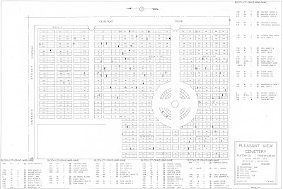
The Pleasant View Cemetery (AKA Pleasant View Union Cemetery) has a Soldiers' Circle. 

Sharing from the Description provided for this cemetery as listed for it on Find a Grave.:
"The Pleasant View Cemetery is located west of Maple Street and south of Ontario Street in the southwest section of the village of Fayette. The older section of Pleasant View Cemetery was a family burial ground on land owned by John Gamber. By 1852 the site had been expanded to serve the local area. The first burial is difficult to determine as grave markers were moved to Pleasant View from abandoned cemeteries. The first burial may have been as early as 1836."

~*~*~*~*~*~*~*~*~*~*~

The Fluhart Cemetery in York Township

Jacob Lozier was an American Revolutionary War veteran.: 

~*~*~*~*~*~*~*~*~*~*~
Phineas Brown - American Revolutionary War veteran who was buried at the Jordan (AKA Edgar) Cemetery

~*~*~*~*~*~*~*~*~*~*~
The Fulton County W.P.A. Cemetery Plat Maps collection is one that has been wonderfully preserved over many decades and is now available for public research; thus ensuring that this valuable information will not be lost! 

Thursday, May 15, 2025

The Ashland County W.P.A. Cemetery Plat Maps have been added to the right sidebar of the Blog.

 The Ashland County W.P.A. Cemetery Plat Maps have been added to the right sidebar of the blog.

The original paper map pages are in a hard cover book at the office of the Ashland County Recorder. Erin Beebe is the Recorder and she has photographed them in their original condition.
~*~*~*~*~*~*~
Sharing this example.:

Selser Cemetery in Milton Township, Ashland County, Ohio.: 

The "Ohio Genealogy Express" lists his name as Frederick Sultzer

~*~*~*~*~*~*~
Unlike most W.P.A. Cemetery Plat Map collections in other Ohio counties, Ashland County's cemetery map pages containing multiple cemeteries on one page are all of the same township. Thus there are no "Multiple Townships / Smaller Cemeteries" category in their collection. 

Monday, April 14, 2025

The Auglaize County W.P.A. Cemetery Plat Maps have been added to the right sidebar of the blog.

The Auglaize County W.P.A. Plat Maps have been added to the right sidebar of the blog.
~*~*~*~*~*~*~*~

Auglaize County, Ohio is comprised of the following townships.:

Clay

Duchouquet

German

Goshen

Jackson

Logan

Moulton 

Noble

Pusheta

Salem

St. Mary's

Union

Washington

Wayne
~*~*~*~*~*~*~*~
The Auglaize County Ohio W.P.A. Cemetery Plat Maps are in pristine condition!  The pages are numbered and the maps are in very good readable condition. 

~*~*~*~*~*~*~*~
The originals for these map pages are at the Auglaize County Recorder's Office in the .pdf format.
~*~*~*~*~*~*~*~
As is the case with these W.P.A. Cemetery Plat Map collections from other Ohio counties, the highest number of veteran burials are for those who served in the Civil War - Number 19.  

There are veterans who served in other wars as well and are noted as such with their number in a circle. 

Fort Amanda Memorial Park is the resting place for two known Revolutionary War veterans.:
Peter Sunderland
Willian Taylor

(age of William Taylor on Find a Grave shows 110 -111, and thus is being investigated.)
~*~*~*~*~*~*~*~
Some map pages present with the veterans names in the more traditional format of listing the veteran's burial location - Section Lot Grave War Name - while other maps show the veteran's name by his gravesite inside the map itself.  

This is a finer point to keep in mind. Below is a side-by-side example that actually occurs on the same map page.: 

~*~*~*~*~*~*~*~
Mentioning that the name for Fort Amanda Memorial Park AKA Fort Amanda Cemetery in Logan Township has been corrected for it on Find a Grave to reflect this name. 

Previously, it had been erroneously identified as being a National Cemetery.  Upon further investigation, it was confirmed that this cemetery is not an official National Cemetery.

When the W.P.A. Cemetery Plat Map was created for it, the word (Military) was included for its name.:

~*~*~*~*~*~*~*~
The Walnut Hill Cemetery in Goshen Township has a penciled in date at the bottom of some of its pages of 3/28/40 which I take it to mean March 28, 1940.  1940 is among the later years when these cemetery plat maps were drawn up in the W.P.A. program which began in the mid to late 1930s during the Great Depression. 


~*~*~*~*~*~*~*~
Thus, if you are researching veteran burials in Auglaize County, Ohio, these W.P.A. Cemetery Plat Maps would be a wonderful place to start!

Friday, February 28, 2025

The Ashtabula County W.P.A. Cemetery Plat Maps have been added to the right sidebar of the blog.

A link to the WPA Cemetery Plat Maps for Ashtabula County has been added to the right sidebar of the blog.  

Along with the customary Cemetery Index Page, there is a Cemetery Locator Map, and a handy listing of cemeteries shown under the township name where they are located.  

These cemetery plat maps are posted in addition to the Ashtabula County G.I.S. website where the cemetery plat maps are further linked to the exact GPS locations on a current road map.
~*~*~*~*~*~*~*~  

Ashtabula County is Ohio's largest county that is comprised of 28 townships.
~*~*~*~*~*~*~*~

Buried in Section F at the East Lenox Cemetery in Lenox Township is American Revolutionary War veteran Isaac Williams whose Find a Grave memorial contains an amazing amount of family history!  He died at the age of 90. 
~*~*~*~*~*~*~*~

Civil War Soldiers and Sailors Monument on Find a Grave  

********
The small Pioneer Cemetery in Windsor Township has a total of 25 memorials on Find a Grave.  The cemetery contains burials of four American Revolutionary War veterans. The W.P.A. Cemetery Plat Map lists their names; and they are the only veterans listed for this cemetery.:

Solomon Griswold

    Capt. Jonathan Parker

Steven Winslow

Giles Loomis 

~*~*~*~*~*~*~*~

The Evergreen Cemetery in Pierpont Township is the final resting place for Seth A. Marvin who was approximately 103 years old when he passed away. His biography states that he cast his first vote for General George Washington for America's first President.  He lived long enough to vote for Abraham Lincoln for President.  

~*~*~*~*~*~*~*~
It is worth a visit to Ashtabula County's cemeteries - both large and small -- where you will find a unique history that abounds within the grounds of them all! 

Monday, January 6, 2025

The Delaware County W.P.A. Cemetery Plat Maps are now up on the right side-bar of the blog.

 WPA CEMETERY PLAT MAPS - DELAWARE COUNTY, OHIO.

Townships in Delaware County, Ohio.:

Berkshire

Berlin

Brown

Concord 

Delaware 

Genoa 

Harlem  

Kingston

Liberty

Marlboro 

Orange

Oxford

Porter

Radnor

Scioto

Thompson

Trenton

Troy

**********

This collection of W.P.A. Cemetery Plat Maps is excellent for quality of the images.  All pages are appropriately numbered.  

It is quite evident when analyzing these pages of cemetery plat maps and the listings of the names of veterans, that Delaware County has a more than an average number of American Revolutionary War veteran burials in its cemeteries. A researcher can grasp a real sense of early American history reviewing these cemetery plat map pages of the veterans names and the wars they served in. 

Seeing the names of so many soldiers who fought in the American Revolution and were buried in Ohio, and specifically in Delaware County, brings a reality to us that the histories we have read about them in books and on the Internet are true. 

For example, The Galena Cemetery cemetery has six burials listed with the number "1" denoting Revolutionary War,  as shown in the Legend Box. 

Mill Creek Cemetery in Scioto Township lists two American Revolutionary War veterans, one of them was Sgt. William Warrington (Page 27 lists his name as William J. Warrington, however, other references show his name as  William E. Warrington) who saved the life of General George Washington.  

Below from FamilySearch.:  

https://ancestors.familysearch.org/en/LWSB-F7P/sgt.-william-e.-warrington-1754-1852
**********

Six Revolutionary War veterans are listed on this page for the Sunbury Cemetery.:

**********

Link to the Columbus Metro Library - Digital Collection 

And this link.

**********

Thus, even though Delaware County's veteran burials are dominated by those who fought in the Civil War, which is the case at other Ohio counties; I feel Delaware County's American Revolutionary War veteran burials number a close second.

Tuesday, December 24, 2024

The Vinton County W.P.A. Cemetery Plat Maps have been added to the right sidebar of the blog.

 A link to the W.P.A. Cemetery Plat Maps for Vinton County, Ohio have been added to the right sidebar of the blog.
~*~*~*~*~*~*~*~*~*~ 
The following townships comprise Vinton County.:
Brown, Clinton, Eagle, Elk, Harrison, Jackson, Knox, 
Madison, Richland, and Wilkesville.
~*~*~*~*~*~*~*~*~*~
Vinton County is mostly a rural county. 
At the time these maps were created during the 1930s, 13 cemeteries had the name Farm included for them.


~*~*~*~*~*~*~*~*~*~
There are 31 map pages that are in the "Multiple Townships - Smaller Cemeteries" category.
~*~*~*~*~*~*~*~*~*~
The Cemetery Index page appears to have been covered with some older type of plastic that has yellowed and wrinkled over time, thus making it more difficult to read all of the cemetery names and numbers for them.

~*~*~*~*~*~*~*~*~*~
There is an Addenda page listing the veterans with unknown burial locations.


~*~*~*~*~*~*~*~*~*~
Note: 

WPA CEMETERY PLAT MAPS - VINTON COUNTY - WILKESVILLE TWP - WILKESVILLE CEM - VETS NAMES INCLUDING AGNES C LAMB - PAGE 46

Agnes was a Major in the WACS during WWII.

~*~*~*~*~*~*~*~*~*~
Also, please note there are penciled-in notations for later wars inside the Legend box for each cemetery.:

 #3 for WWII, #5 for the Korean War, and #7 for the Vietnam War.  

Further note, however, these numbers do not correspond with the original and official W.P.A. Cemetery Plat Map numbers that were created during the time the program was in place, which was during the 1930s.  Those numbers were assigned to other wars.:

#3 - Warfare with Indians on the frontier.
#5 - War with France
#7 - War with Tripoli.
~*~*~*~*~*~*~*~*~*~
The overall condition of these maps is fair to poor with the Cemetery Index Page being in the most unreadable condition unfortunately.